 Where
is It?
Where
is It? Tracking The Magnetic North Pole
During the sixteenth century, mariners believed that somewhere in the North was a magnetic mountain that was the source of attraction for compasses, and, unfortunately, for any ships that strayed too close to it. It was not until 1600 that someone came up with a better idea. Sir William Gilbert, physician to Queen Elizabeth I, suggested that the Earth itself was a giant magnet and that the force that directed the compass originated inside the Earth. Using a model of the Earth made from lodestone (a naturally occurring magnetic rock), he also showed that there should be two points on the Earth where a magnetized needle would stand vertically at the North and South Magnetic Poles.
This is basically the same definition used today. At the magnetic poles, the Earth's magnetic field is perpendicular to the Earth's surface. Consequently, the magnetic dip, or inclination (the angle between the horizontal and the direction of the earth's magnetic field), is 90°. And since the magnetic field is vertical, there is no force in a horizontal direction. Therefore, the magnetic declination, the angle between true geographic north and magnetic north, cannot be determined at the magnetic poles.
Where
is It?
Gilbert believed that the North Magnetic Pole coincided with the north geographic pole. Magnetic observations made by explorers in subsequent decades showed that this was not true, and by the early nineteenth century, the accumulated observations proved that the pole must be somewhere in Arctic Canada.
In 1829, Sir John Ross set out on a voyage to discover the Northwest Passage. His ship became trapped in ice off the northwest coast of Boothia Peninsula, where it was to remain for the next four years. Sir John's nephew, James Clark Ross, used the time to take magnetic observations along the Boothia coast. These convinced him that the pole was not far away, and in the spring of 1831 he set out to reach it. On June 1, 1831, at Cape Adelaide on the west coast of Boothia Peninsula, he measured a dip of 89° 59'. For all practical purposes, he had reached the North Magnetic Pole.
The next attempt to reach the North Magnetic Pole was made some 70 years later by the Norwegian explorer Roald Amundsen. In 1903 he left Norway on his famous voyage through the Northwest Passage, which, in fact, was his secondary objective. His primary goal was to set up a temporary magnetic observatory in the Arctic and to re-locate the North Magnetic Pole.
A pole position was next determined by Canadian government scientists shortly after World War II. Paul Serson and Jack Clark, of the Dominion Observatory, measured a dip of 89° 56' at Allen Lake on Prince of Wales Island. This, in conjunction with other observations made in the vicinity, showed that the pole had moved some 250 km northwest since the time of Amundsen's observations. Subsequent observations by Canadian government scientists in 1962, 1973, 1984, and most recently in 1994, showed that the general northwesterly motion of the pole is continuing, and that during this century it has moved on average 10 km per year .
Diurnal
Motion of the Pole 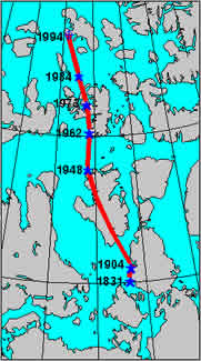
It is important to realize that when we talk about the location of the pole, we are referring to an average position. The pole wanders daily in a roughly elliptical path around this average position, and may frequently be as much as 80 km away from this position when the Earth's magnetic field is disturbed. The diagram shows the average path on a magnetically quiet day (inner elipse) and on a magnetically disturbed day (outer ellipse).
Why is the Pole Moving?
If, as Gilbert believed, the Earth acts as a large magnet, the pole would not move, at least not as rapidly as it does. We now know that the cause of the Earth's magnetic field is much more complex. We believe that it is produced by electrical currents that originate in the hot, liquid, outer core of the Earth. As a simple analogy, consider an electromagnet, in which we can produce a strong magnetic field by passing an electric current through a coil of wire.
In nature, processes are seldom simple. The flow of electric currents in the core is continually changing, so the magnetic field produced by those currents also changes. This means that at the surface of the Earth, both the strength and direction of the magnetic field will vary over the years. This gradual change is called the secular variation of the magnetic field.
The position of the North Magnetic Pole is strongly influenced by the secular variation in its vicinity. For example, if the dip is 90° at a given point this year, that point will be the North Magnetic Pole, by definition. However, because of secular variation, the dip at that point will change to 89°58' in about two years, so it will no longer be the pole. However, at some nearby point, the dip will have increased to 90°, and that point will have become the pole. In this manner, the pole slowly moves across the Arctic.
The more rapid daily motion of the pole around its average position has an entirely different cause. If we measure the Earth's magnetic field continually, such as is done at a magnetic observatory, we will see that it changes during the course of a day, sometimes slowly, sometimes rapidly. The ultimate cause of these fluctuations is the Sun. The Sun constantly emits charged particles that, on encountering the Earth's magnetic field, cause electric currents to be produced in the upper atmosphere. These electric currents disturb the magnetic field, resulting in a temporary shift in the pole's position. The distance and speed of these displacements will, of course, depend on the nature of the disturbances in the magnetic field, but they are occurring constantly. When scientists try to determine the average position of the pole, they must average out all of these transient wanderings.
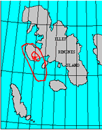 1994
North Magnetic Pole Survey
1994
North Magnetic Pole Survey
In April and May of 1994, Larry Newitt, of the Geological Survey of Canada, and Charles Barton, of the Australian Geological Survey Organisation, conducted a survey to determine the average position of the North Magnetic Pole at that time. Working out of Resolute Bay, N.W.T., they established a temporary magnetic observatory on Lougheed Island, close to the predicted position of the pole. This allowed them to monitor the short-term fluctuations of the magnetic field that result in the daily motion of the pole.
In addition, the strength and direction of the magnetic field were measured at this site, and at seven additional sites in the region. From these observations, the point at which the average dip was 90° could be determined.
They determined that the average position of the North Magnetic Pole in 1994 was located on the Noice Peninsula, southwest Ellef Ringnes Island, at 78.3° N, 104.0° W. The yearly motion of the pole has increased, and is now 15 km per year.
What is the Interest for Canada?
The reasons that the pole generates so much interest have changed over the years. For Ross, the search for the pole was a byproduct of scientific nationalism. For Amundsen, it offered a good excuse to sail through the Northwest Passage. Today, we are interested in the pole as a tool for magnetic cartography.